TEMPO Instrument
The TEMPO instrument is a grating spectrometer sensitive to visible and ultraviolet wavelengths of light which is attached to the Earth-facing side of the commercial telecommunications satellite IS-40e in geostationary orbit. This vantage point allows TEMPO to maintain a constant view of North America so that the instrument's light-collecting mirror can make a complete East to West scan of the field of regard each and every hour during daytime. By measuring sunlight reflected and scattered from the Earth's surface and atmosphere back to the instrument's detectors, TEMPO's ultraviolet and visible light sensors provide measurements of ozone, nitrogen dioxide, formaldehyde, aerosols and other atmospheric constituents important for understanding air quality and the chemistry of Earth's atmosphere.
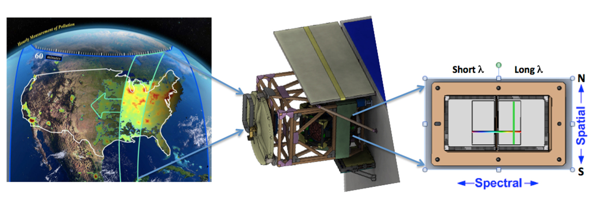
Schematic of TEMPO Spectrometer
© NASA/BATC/SAO.
The instrument's optical system resolves four square miles per ground pixel, so that variations in air quality can be observed at sub-urban scales. TEMPO measures hourly variations in trace gases and aerosols, enabling researchers, air quality managers, policy makers and public citizens to better monitor the changing "chemical weather" locally, regionally and across the continent.
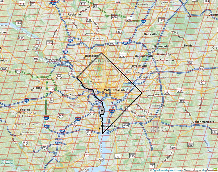
TEMPO can track variations in air quality at sub-urban scales. Each orange rectangle represents the footprint of a single pixel.
© OpenStreetMap contributors/SAO.
The key instrument characteristics and capabilities include:
- Spectral range: 293–741 nm (UV, visible); spectral sampling: 0.2 nm; spectral resolution: 0.6 nm. Two 2D detectors (2048 x 1028 pixels) image the full spectral range except for a gap from 494–538 nm for each geospatial scene.
- Spatial resolution: 2 km/pixel in the North-South direction, 4.75 km/pixel in the East-West direction at the center of the field of regard (33.5° N, 89.2° W). Due to the intense computational requirements for the ozone profile product, this product uses co-added spectra and is calculated at a resolution of 8 km N/S x 4.75 km E/W.
- Temporal resolution: Nominal hourly measurements involve stepping the scan mirror East to West over the entire field of regard 1181 times (resulting in 2.4 million spectra/hour). Shorter 40-minute scans occur over the eastern (morning) or western (evening) part of the continent when the other side of the continent is in darkness.
- High time resolution (10 minutes or less) “special operations” occur on occasion where a limited East-West region is scanned at high frequency. These can be performed for special science experiments, or to respond to events like wildfires, dust outbreaks, or volcanic eruptions.
- Twilight radiances are routinely collected before sunrise for examining city lights and natural phenomena like aurora.